The physical structure of the GFBF was studied by joint collaborations between groups in the fields of biogeochemistry, geography, hydrology, climatology, glaciology and oceanography. Economic flows, land-use background analyses, and a conservation strategy for the system were studied by scientists in the fields of forest engineering, agronomy, economic geography, international law and politics. This project is composed of 10 research groups headed by group leaders. The project leader and 10 group leaders constitute the board of the project. In addition to individual group meetings, at least one project meeting was held each year to discuss cross boundary issues. Daily communications and discussions were carried out through an Internet mailing list. The themes/tasks of each research group are as follows. There are no substantial changes in methodologies employed by Groups 1 to 9 after the Interim Evaluation in March 2007. Group 10 was newly established and is responsible for designing a conservation strategy for the GFBF based on the results obtained by Groups 1-9. |
|
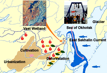 Figure 1. Study Area Figure 1. Study Area |
|
Group 1: Physical oceanographic conditions | Group 2: Geochemical and biological conditions | Group 3: Transport of biogeochemical materials | Group 4: Biochemical transport from terrestrial ecosystem | Group 5: Background of the anthropogenic impacts | Group 6: Spatial and historial monitoring of land-use changes | Group 7: Estimate of atmospheric transports of terrestrial materials | Group 8: Natural variability of the hydro-metrological and hydro-chemical conditions | Group 9: Modeling of biomass production | Group 10: conservation strategy for the GFBF |
|
☆ ☆ ☆ ☆ ☆ ☆ ☆ |
|
Group 1 (GL: Dr. Kay I Oshima) Physical oceanographic conditions in the Sea of Okhotsk and the northern North Pacific. This group carried out physical oceanographic observations aiming to quantify the flux of the East Sakhalin Current and water exchange across Bussol Strait, all of which are essential in estimating the iron flux in the Sea of Okhotsk and Oyashio region. Special attention was paid to the role of sea ice in the Sea of Okhotsk, which was supposed to be a driver of in the Sea of Okhotsk. |
|
| Group 2 (GL: Dr. Takeshi Nakatsuka) Geochemical and biological conditions in the Sea of Okhotsk and the northern North Pacific. This group embarked on research cruises in the Sea of Okhotsk and adjacent areas and focused on the spatial distribution of chemical and biological properties to investigate the source and transportation of dissolved iron. In situ observations of phytoplankton in the Sea of Okhotsk and Oyashio region were also conducted. |
|
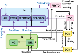 Figure 2. Scheme of numerical marine biological model in the Sea of Okhotsk Figure 2. Scheme of numerical marine biological model in the Sea of Okhotsk |
|
Group 3 (GL: Dr. Seiya Nagao)
Transport of biogeochemical materials from the Amur River to the Sea of Okhotsk. This group conducted three different observations: the monthly monitoring of water quality at Khabarovsk, Bogorodtskoe and Nikoraevsk-na-Amure, on research cruises along the lower reaches of the Amur River, and observations of water samples collected on research cruises in the estuarial area of the Amur River. These field samplings and the analyses provided a basic idea of how dissolved iron was transported from the Amur River to the Sea of Okhotsk. 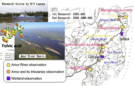 Fig 3. Landform and drainage pattern in the Amur River basin Fig 3. Landform and drainage pattern in the Amur River basin |
|
| Group 4 (GL: Dr. Hideaki Shibata) Biogeochemical transport from the terrestrial ecosystem to the Amur River. This group continuously monitored water quality on various land surfaces including natural forest, forest damaged by fire, wetlands, paddy fields and upland fields in Russia and China. The Sanjiang plain was of particular interest since this vast plain was largely covered with wetlands but has been most intensively reclaimed during the last 20 years of the 20th century. 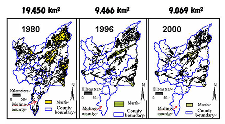 Fig 4. Changes in wetland-area in Sanjiang Plain from 1980 to 2000. Fig 4. Changes in wetland-area in Sanjiang Plain from 1980 to 2000. |
|
| Group 5 (GL: Dr. Hiroaki Kakizawa) Background of anthropogenic impacts in the Amur River basin. This group analyzed the background behind forest management, agricultural policy and timber trading both in Russia and China. The group paid special attention to the international driving forces behind these socio-economic situations. 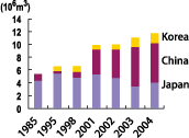 Figure 5. Time-series of timber export
to Japan, China and Korea Figure 5. Time-series of timber export
to Japan, China and Korea |
|
| Group 6 (GL: Dr. Shigeko Haruyama) Spatial and historical monitoring of land-use changes in the Amur River basin. This group attempted to visualize spatial changes in land uses in the Amur River basin by means of satellite image interpretation, field work and statistical analyses. |
|
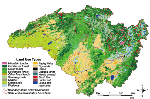 Fig6. Present day land-uses in the whole Amur River basin Fig6. Present day land-uses in the whole Amur River basin |
|
| Group 7 (GL: Dr. Sumito Matoba) Estimation of the atmospheric transport of terrestrial material. This group extended a real-time observation network for aerosol deposition around the Sea of Okhotsk. It also conducted ice-core drilling to reconstruct the past atmospheric input of iron to the study area. 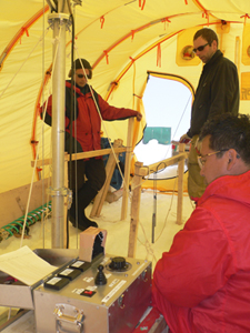 Fig.7 Fig.7 |
|
| Group 8 (GL: Dr. Takeo Onishi) Numerical modelling of basin-scale hydrology and iron transport. This group attempted to develop a numerical hydro-geochemical model with special emphasis on iron dynamics for the Amur River basin. 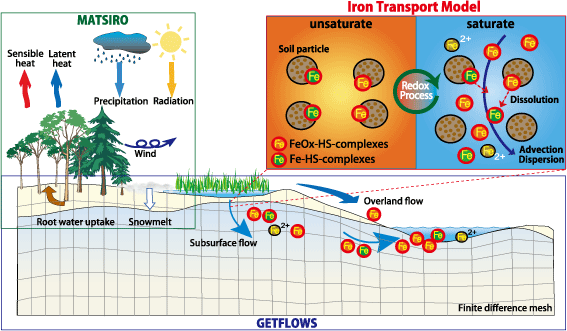 Fig.8
Fig.8 |
|
| Group 9 (GLs: Drs. Hiroyuki Matsuda and Fumio Mitsudera) Numerical modelling of iron transport in the Sea of Okhotsk and the northern North Pacific. This group attempted to develop a numerical ocean ecosystem model to simulate the importance of dissolved iron to the phytoplankton in the Sea of Okhotsk and Oyashio region. The model was lately modified by including physical code to describe the which was considered to be the main source of current transporting the dissolved iron to the Oyashio region. 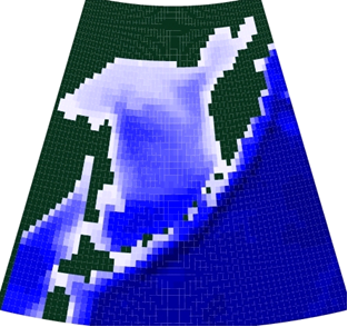 Fig. 9 Model domain and bottom topography Fig. 9 Model domain and bottom topography |
|
| Group 10 (GL: Mr. Yasunori Hanamatsu) Conservation strategy for the GFBF. This group was established just recently and will to find a framework for conserving theGFBF. The group reviewed all international and domestic laws and institutions that were originally created to address particular aspects of the environment in this region. 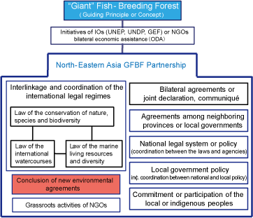 Fig. 10 Agenda Map Fig. 10 Agenda Map |
|
Copyright2005 Amur-Okhotsk Project@RIHN All right reserved.