Historical Interactions between Multi-Cultural Societies and the Natural Environment in a Semi-Arid Region in Central Eurasia
2013 CR
Human beings have continually strived to adapt to changes in the environment. This project combined analysis of historical documents, archaeological remains and natural proxies such as ice cores, lake sediment samples, and tree rings in order to describe the history of adaptations by human beings to both environmental and societal changes in arid to semi-arid regions of Central Eurasia. Project research focused particularly on use of natural resources in order to provide some historical depth to contemporary discussion of global environmental problems.
The project reconstructed climate change in the area over the past one thousand years. Temperature and precipitation data indicated that the period from AD1000 to AD1500 was warm and dry, while the Little Ice Age (LIA), from 1500 to 1850 was cold and wet. We also estimated two important factors relating agriculture to nomadic activities, namely, river flow and distribution of grassland. The long-term trend of river flow corresponds well with the reconstructed lake level of Lake Balkhash, indicating that lake levels decreased from the 10th to 13th century. A chronological database describing the rise and fall of settlements indicates a clear change in the distribution pattern of agricultural settlements in the Syr Darya Delta from the 13th to 15th centuries. The change in settlement pattern is associated with shifting river courses which are also associated with severe decline of the Aral Sea lake level in the 13th to 15th centuries.
The warm and dry climate in early medieval times might have accelerated the development of agricultural and trading activities, and consequently contributed to the flourishing of the area, especially oasis cities in the Syr Darya basin of western Turkestan from the 7th to 13th centuries. The cold and wet climate in the LIA might be associated with the decline of oasis cities and increase of nomadic activities of the period, as nomadic population groups and place-names identified in historical documents show that nomadic groups expanded their activities in the new grasslands in the 17th and 18th centuries. Such cultural and ecological shifts demonstrate that ecosystems in Central Eurasia have wide range of natural variation, but also have fluctuated due to climate change. Social flexibility, such as high mobility and subsistence complex patterns were major ways of adaptation to this environment. Also, societal mobility sometimes reduced societal conflicts.
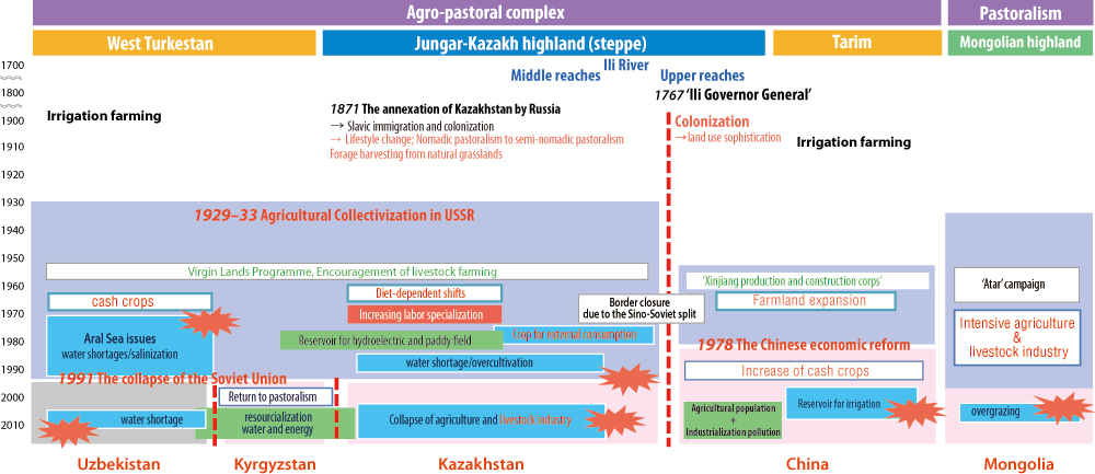
After a long transition marked by the rise and fall of various ethnic groups and countries, a secure and definite border divided the region between Russia and Qing in the 18th century. The people of the area experienced a great change in their lifestyle, caused by the introduction of modern agriculture. The settlement policy and collectivization of the agricultural sector from 1929 triggered social confusion in Kazakhstan, resulting in the loss of a large number of nomadic populations. Under the “transformation of nature” ideology of the Soviet Union, Kazakhstan was forced to become one of the major crop production areas in the Soviet Union, causing excessive development, which ignored environmental capacity and exerted significant impact on the area. In addition, these development policies were applied in a fashion that ignored and destroyed traditional social systems. In particular, the new production system, including the division of labor, together with the migration of skilled peoples from other countries as leaders for collective farms, prevented the accumulation of agricultural knowledge, and also caused the loss of traditional knowledge of nomadic pastoralism and its subsistence complex. Moreover, societal confusion caused by the collapse of the Soviet Union implies that societal flexibility in the area could be a very important factor in the resilience of society to both natural and societal impacts. This is one of the keys to understanding contemporary environmental issues in Central Eurasia.