Environmental Change and the Indus Civilization
2013 CR2
The Indus Civilization (2600 BC–1900 BC) is one of the four great ancient civilizations. It is known for its cultural and technological achievements—its characteristic seals and scripts, fortified settlements and drain systems—and also for its brief tenure. Its sites spread over 680,000 sq. km., not only along the Indus River but also along the Ghaggar River and in the Gujarat state of India. Drawing on archaeology, Indology, and palaeo-environmental investigation, this project attempted to determine whether and how environmental factors contributed to their short life and rapid decline. Especially through palaeo-environmental investigation, it also attempted to enhance understanding of the relationship between long- and short-term environmental changes and human civilizations, and thus contribute to contemporary debates of environmental change.
Principal findings
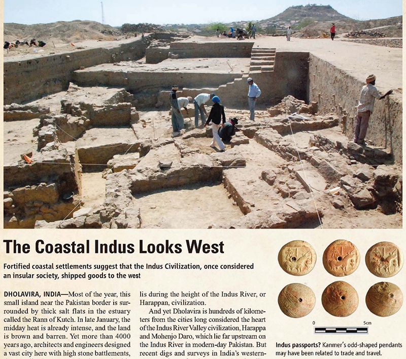
Photo From SCIENCE 328: 1100 (2010) Reprinted with permission from AAAS
Our research on environmental changes centered around three issues. The first concerns the long-standing debate about the Ghaggar-Hakra River. It was identified as the ‘mighty’ Sarasvati River in the Rig-Veda text, and therefore considered critical to Indus agricultural systems. Our team, however, established that in the Indus period the Ghaggar was much as it is today, a rather small river highly affected by monsoon.
The second issue is the sea level change during the Indus period. Sea trade between Indus regions and the west was somewhat reconstructed through study of Mesopotamian cuneiform texts. Additionally, artifacts discovered at sites in Gujarat clearly indicate that they were centers of trade with Mesopotamia and Africa. Our examinations of sea level change indicate that the important seaport Lothal fell out of use in the first millennium BC, suggesting that regional environmental change was related to the decline of trade along the coast of Gujarat.
Thirdly, our palaeo-environmental team extracted cores from Rara Lake in the Lesser-Himalayan region in 2009 in order to reconstruct long-term climate changes in South Asia. The analysis of these cores established that the summer monsoon intensified as the Indus civilization declined.
Due to the outcome of these studies we conclude that Indus Civilization underwent a process of transformation due to population migration from the Indus river basin to monsoon affected areas, causing gradual disintegration of trade network which connected different regions of the Indus society. This migration was caused by both long- and short-term environmental changes. The Indus declined; it did not collapse suddenly due to drastic natural or social events.
Our contributions to Global Environmental Issues
As Jared Diamond showed in his celebrated book “Collapse”, past civilizations teach us many things. The regional diversity of natural and social environment and the trade network connecting different regions found in the Indus Civilization remind us of modern Indian societies rather than the other ancient civilizations. This diversity of South Asian societies which apparently continued from the Indus period is something we need to value when we think about the future of this Earth. In addition, the proxy data obtained from Rara Lake cover not only the Indus period but the period of over several thousand years. We consider that they will be useful to the future study of climate change on a global scale.
▲PAGE TOPResearch communication
When we presented the outcome of our research at the conference of South Asian Archaeology in Paris in July 2012, Professor Mark Kennoyer, authority of the Indus archaeology, congratulated the completion of our project, saying that the project had made a great contribution to the South Asian archaeology. Currently we are trying to start a new project which will inherit the outcome of the Indus project. As regards academic publications, our presentation at the Chapman meeting of AGU in March 2011 proving that the Ghaggar was not a mighty river was finally published in the monograph of the meeting. Other publications are listed on the RIHN project website.
▲PAGE TOP